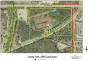
Park Lay-out map
This image shows the initial Park Lay-out plan aerial view with markers
for the approximate location of the photographer (in black capital letters)
in each picture shown below. Also shown is the approximate locations of
the track, building, parking area, sign, entrance and other items from
above. With this image and the pictures below you may be able to get a
mental image of the property and items to be built.
Park Lay-out .gif Medium size (333K)
Park Lay-out .pdf Full size (11 Megabytes)
During 2008 we took a few pictures. We started work on
drainage, parking and the track area. Most of this work is complete or
at least roughed in. We also had a burst of events the last 2 months
with dirt being delivered. Due to our land the dirt was dumped where the
track was to be built. Once the dirt was delivered we had to move it
off the area we are using for the track. Moving 5000 yards of dirt
is a lot of work.
The files are arranged like the first set of pictures from back in
January 2007 and some are from the same viewing point as shown above
in the
Park Lay-out map above.
Listed oldest to newest.
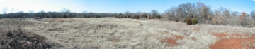
A - Center looking west
Here we are standing on the west side of our future building. Some of
these are full 360° panoramic views. In some pictures you can see a
truck parked in the driveway, the truck is parked at the entrance gate.
Image dated 09-10-2008 was taken after the ditches on the south side of
the track area were cut and the culverts were installed.
01-28-2007:
A Full size (3.8meg).
09-10-2008:
A Full size (6.4meg).
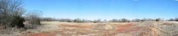
B - Beside entrance gate
These pictures were taken from the entrance gate or nearby.
From here the track will be located about 100 feet to the
north. Lots of open space for a race track! Most of the dirt we will use
to build the track will have to be trucked in to the site.
Image dated 09-02-2008 was taken about 50 feet north of the entrance
gate. It is a 360° pan.
Image dated 12-06-2008 was taken about 100 feet north of the entrance
gate. The Starting Hill is now larger, no dirt has been delivered.
Image dated 12-12-2008 was taken about 90 feet north of the entrance
gate. The Starting Hill is now larger, about 25% of the dirt has been
delivered.
Image dated 12-28-2008 was taken about 150 feet north and 100 feet east
of the entrance gate. The 'Hill' has a truck parked at the bottom.
01-28-2007:
B Full size (3.1meg).
09-02-2008:
B Full size (5.7meg).
12-06-2008:
B Full size (1.9meg).
12-12-2008:
B Full size (2.1meg).
12-28-2008:
B Full size (2.4meg).
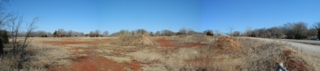
C - Gate looking east
If you stood at the entrance gate to the property this is what you would
have seen. The left side is north and the right side is east. This is
several feet west of the image above 'B'. You can see the berm on the
east side of the gate (far right bottom). Just to the left of the berm
is a pile of dirt, that is about where our new sign will be located.
From here our building will be located about 200 away between the gate
and the tower in the middle top of this picture.
01-28-2007:
C Full size (2.8meg).
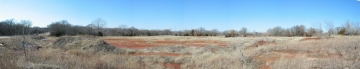
G - Looking west
The picture pans from the southwest (left of image) to the north (right
of image) from about the middle (east to west) of the properties Grand
Boulevard frontage. As in most of these pictures you can see the truck
parked in the entrance. This view shows the open area where the track
will be built. Also near the far right are 2 individual trees with a
bald spot to there left, to their right is a evergreen (cedar) tree.
The space between those trees is where our building will be located.
The location where this picture was taken is about 12 feet higher in
elevation (uphill) from the entrance gate. The area from the middle of
this picture to the right and between the truck and the photographer is
the area we will be terracing and landscaping.
01-28-2007:
G Full size (3.4meg).
D - Near staging area
This image was taken from about where staging will be located then the
new track is built. The 2007 picture was taken from on top of the
existing pile of dirt which became our new Starting Hill. The 2007 image
is a 360° panoramic, some others are not.
The image dated 09-02-2008 was taken just after we started to work on
the Starting Hill with our Bobcat.
The image dated 12-28-2008 was taken on the Starting Hill. Looking down
the 1st straight. All jumps and turn has changed. The 'Hill' has had
more dirt added since this was taken.
01-28-2007:
D Full size (8.3meg).
11-02-2008:
D Full size (2.9meg).
12-28-2008:
D Full size (2.5meg).
E - Near middle of 1st straight
Here we are standing by an old electric pole, the 3rd from the left to
right in the image 'D' above. The left of the image is looking south
where the truck is parked and about the middle from left to right is
looking north into some close trees. About 3/4 of the way from the left
to right we are looking back to the east where the start hill will be
located. This image is from about half way down the right side of the
1st straight of the track.
01-28-2007:
E Full size (9.4meg).
F - Near 3rd turn
Here we are standing by an old electric pole, the 2rd from the left to
right in the image 'D' above. The far left of the image is looking south
where the truck is parked, the very front of truck is visible in the
full size image. To the left of the power pole is the front of the truck
and the entrance gate. About 1/3 of the way across from left to right is
a power pole so close you could touch it. That pole is about where the
center of the 3rd turn will be located on the track. About 2/3 of the
way across from left to right another power pole, that pole is the
location where the above picture 'E' was taken. About 3/4 of the
way across from left to right is a cell tower in the background, to the
left of the tower are some short trees and farther left are a few
evergreen (cedar) trees. This is the location of our building, from the
view we would be looking at the northwest side of the building. This
picture shows a lot of snow on the ground and on the north sides of
some piles of dirt.
01-28-2007:
F Full size (7.8meg).