Trosper Park pictures, January 28, 2007
Trosper Park land before the NEW Sooner Pearl track.
Pictures seen here from a group of pictures taken January 28, 2007. These pictures show the land as it was before our lease agreement with the City of Oklahoma City Parks & Recreation Department.
These pictures and the location of the photographer can be referenced using the Park Lay-out map below. Please note these pictures were taken well before the 'ICE STORM 2007' and many of the trees shown were heavily damaged due to ice. Some will be removed due to damage and many will not appear like this for years if ever again.

WARNING
The panoramic views are made using multiple images. The FULL SIZE panoramic views are available uncropped, these images are large files. The medium sized images are reduced 50% from the originals, they will load faster if you are in a hurry or picture detail. File sizes are shown with each picture.
The Park Lay-out image has 2 links, the MEDIUM will open in a browser window and is much smaller in size and detail. The FULL SIZE Park Lay-out image is a .pdf file. You will need to make sure you have a .pdf reader to view this file.
get_adobe_reader (2K)
All photographs are © copyright okbmx.com. Use or duplication without permission is prohibited.
TOP OF PAGE
Park Lay-out map
This image shows the initial Park Lay-out plan aerial view with markers for the approximate location of the photographer (in black capital letters) in each picture shown below. Also shown is the approximate locations of the track, building, parking area, sign, entrance and other items from above. With this image and the pictures below you may be able to get a mental image of the property and items to be built.
Park Lay-out .gif Medium size (333K)
Park Lay-out .pdf Full size (11 Megabytes)
TOP OF PAGE
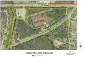
On January 28, 2007 it was time to start looking at the land for the new track at Trosper Park. In order to get a handle on things we decided to get some pictures for future reference. These pictures are shown as a thumbnail image below with links to both a medium size and full size image. Files sizes are shown with each link.
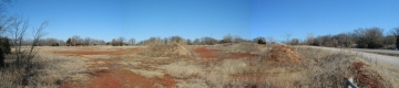
It was a nice cool day with bright clear skies, things are a little wet since there was snow on the ground earlier in the day.
tn_center_looking_west.jpg (24K)
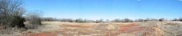
A - Center looking west
Pan looking west, north is the right side of image and south is the left side of the image. Looking in the center slightly to right there is a line of trees, those trees will be on the north side of the race track. Also looking to the center you would be looking down the 2nd straight of the track. You can see a truck parked in the driveway in the left side of the image the truck is parked at the entrance gate. Shown are the old electrical service poles for the old BMX track, the new track will be between those poles.

A Medium size (2.7meg).
A Full size (3.8meg).
tn_from_gate.jpg (22K)
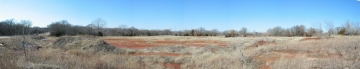
B - Beside gate looking north
This picture was taken from the east of the entrance gate standing on a pile of dirt beside the gate. To the left is looking north and to the right is east. From here the track will be located about 100 feet to the north, toward the pole in the center of this picture. Lots of open space for a race track! The land is somewhat level and there is a small amount of dirt we will be using from the site. Most of the dirt we will use to build the track will have to be trucked in to the site. The area on the right side of this picture will be terraced and landscaped, all of the piles of dirt will be used for landscaping.

B Medium size (2.4meg).
B Full size (3.1meg).

tn_from_gate_looking_east.jpg (23K)
C - Gate looking east
If you stood at the entrance gate to the property this is what you would have seen. The left side is north and the right side is east. This is several feet west of the image above 'B'. You can see the berm on the east side of the gate (far right bottom). Just to the left of the berm is a pile of dirt, that is about where our new sign will be located. From here our building will be located about 200 away between the gate and the tower in the middle top of this picture.
C Medium size (2.3meg).
C Full size (2.8meg).
tn_looking_west.jpg (22K)
G - Looking west
The picture pans from the southwest (left of image) to the north (right of image) from about the middle (east to west) of the properties Grand Boulevard frontage. As in most of these pictures you can see the truck parked in the entrance. This view shows the open area where the track will be built. Also near the far right are 2 individual trees with a bald spot to there left, to their right is a evergreen (cedar) tree. The space between those trees is where our building will be located. The location where this picture was taken is about 12 feet higher in elevation (uphill) from the entrance gate. The area from the middle of this picture to the right and between the truck and the photographer is the area we will be terracing and landscaping.
G Medium size (2.6meg).
G Full size (3.4meg).
TOP OF PAGE
These last images are 360 degree panoramic views. The images are from the north edge of the open area where the track will be built. These are large image files and may take some time to download if you are using a dial up connection. The medium size files would download somewhat faster on dial up.
tn_looking_south_360.jpg (36K)
D - Near staging area
This image was taken from about where staging will be located then the new track is built. On the left is looking east about 1/3 of the way right you can see the truck almost hidden by a pile of dirt. That pile of dirt disappeared just before we got the lease for this property. At about 1/2 way from left to right you are looking down what will be the left side of the 1st straight on the track, near the 3rd power pole from the left. All 4 poles are visible in this image. We will be using 2 of those existing poles for lighting in the future.
D Medium size (6.5meg).
D Full size (8.3meg).
tn_looking_south_again_360.jpg (44K)
E - Near middle of 1st straight
Here we are standing by an old electric pole, the 3rd from the left to right in the image 'D' above. The left of the image is looking south where the truck is parked and about the middle from left to right is looking north into some close trees. About 3/4 of the way from the left to right we are looking back to the east where the start hill will be located. This image is from about half way down the right side of the 1st straight of the track.
E Medium size (6.2meg).
E Full size (9.4meg).
tn_looking_south_last_pole_360.jpg (39K)
F - Near 3rd turn
Here we are standing by an old electric pole, the 2rd from the left to right in the image 'D' above. The far left of the image is looking south where the truck is parked, the very front of truck is visible in the full size image. To the left of the power pole is the front of the truck and the entrance gate. About 1/3 of the way across from left to right is a power pole so close you could touch it. That pole is about where the center of the 3rd turn will be located on the track. About 2/3 of the way across from left to right another power pole, that pole is the location where the above picture 'E' was taken. About 3/4 of the way across from left to right is a cell tower in the background, to the left of the tower are some short trees and farther left are a few evergreen (cedar) trees. This is the location of our building, from the view we would be looking at the northwest side of the building. This picture shows a lot of snow on the ground and on the north sides of some piles of dirt.
F Medium size (6.2meg).
F Full size (7.8meg).
TOP OF PAGE
© 2001-2009 Red Oak Resources, All Rights Reserved.
Last updated Tuesday February 03,2009 10:59 PM
Build date Sunday January 27,2008 02:47 AM
Trademarks and registered trademarks are property of their registered owners.
E-mail about this site:webmaster
Valid HTML 4.01! Valid CSS!